Price per person in a double room with the general ticket
The offer is valid from the beginning of July until the end of September 2024 (depending on the snow situation in the Saas Valley, even earlier or later bookings possible).
During the summer holidays only on request.
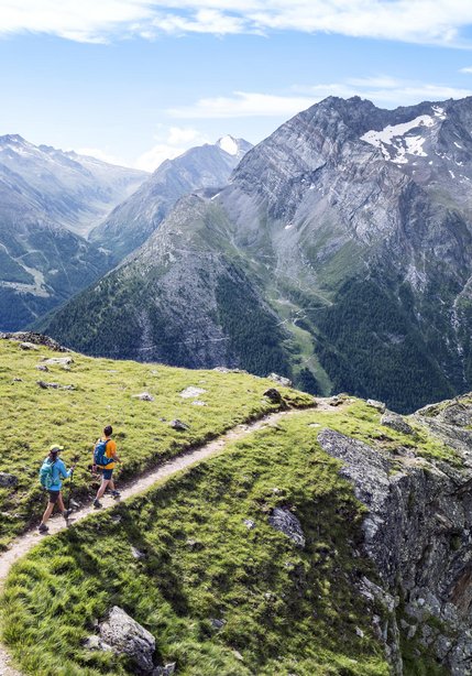
In Saas-Fee erwartet Sie ein vielfältiges Wander-Paradies mit 350km Wegen. Auf den Wanderwegen geniessen Sie immer wieder neue Perspektiven auf die umliegenden Viertausender – unteranderem auch auf den Dom, der höchste Berg der Schweiz! Ganz bestimmt begegnen Sie dabei auch dem einen oder anderen Murmeltier - den wohl süssesten Dorfbewohnern von Saas-Fee. Lohnenswert ist ein Ausflug mit der höchsten U-Bahn der Welt: die Metro Alpin. Gipfelstürmer haben von hier aus auch die Möglichkeit mit einem Bergführer einer der einfachsten Viertausender in der Schweiz zu besteigen, das Allalinhorn.
Gemsweg (2h30):
From the town centre, walk across the panoramic bridge as far as Grundbiel. Here, follow the irrigation canal as far as the “Gletschergrotte” mountain restaurant. Then continue on the intermediate- difficulty hiking trail to the summit of the Hannig from where you can catch the cable car back to the town centre.
Hinter dem Mittaghorn (3h30):
A popular intermediate-difficulty hiking trail setting off opposite the Felskinn cable car station via the Fee and Chessenjen glaciers to the Egginerjoch.
Summiteer Glacier Trail (4h30):
high-altitude Alpine hike departing from the Felskinn cable car station, via the Chessenjen glacier and the Egginerjoch to the Britannia hut. The way down takes you across the Hohlaub glacier and the Allalin glacier. The route goes over the glaciers, is well-signposted and is easy to negotiate. This hiking route is only suitable for experienced hikers.
Saas-Fee to Zermatt is possible in a day, with the help of the Stalden – Gspon cable car, the Matterhorn Gotthard railway and your own two feet! You begin your hike in the town centre of Saas-Fee. Taking the Kapellenweg, you will descend to Saas-Grund. From there the route leads uphill through the forest until you reach a beautiful high-altitude path that will lead you to Gspon. The path is lined by sun-burnt granges, barns and stables and offers an imperious view of the Mischabel mountain range! You’ll be tackling 850 metres of elevation but to make life easier, you can cut out a lot of the ascent with the Hohsaas cable car from Saas-Grund to Kreuzboden. From Gspon you can get the cable car to Stalden from where you can take the Matterhorn Gotthard railway on towards Zermatt.
Details of the hike can be found further down under "Route and map material".
Over 400 kilometres of signposted hiking paths criss-cross the summer paradise of Zermatt. Relaxed-pace family hikes are just as possible as more dizzying Alpine treks. In the background, like an ever-present companion, the Matterhorn – both fearsome myth and most-photographed icon of the region.
Unsere Top-Wandertipps in der Region Zermatt:
Prices per person for 4 nights in a | double room standard |
| With GA Travelcard | CHF 1'135.- |
| With Half-Fare Card | CHF 1'165.- |
| Without reduction | CHF 1'175.- |
WEEKEND SUPPLEMENT FOR FRIDAY AND SATURDAY NIGHT IN ZERMATT: CHF 50.- PER PERSON AND NIGHT
Would you like to book this offer? Then contact us via phone
The Private Selection Hotel Service AG is part of the guarantee fund of the Swiss tourism sector and ensures the repayment of your deposit paid in connection with the booking of a package as well as your return journey. For further details kindly ask Private Selection Hotels or on www.garantiefonds.ch.
![[Translate to English] wandern Saastal](https://res.cloudinary.com/dgr25kh64/image/fetch/c_fill,f_auto,h_417,q_80,w_980/https://private.spotwerbung.ch/storage/img/iNhX26bcRZSEzmCHS4CilJ2iIVKYU0aMuiWnOUVP.jpeg)

